Blue Feather Unveils Digital Twin of Lugano: A New Standard in Urban Intelligence
- AlexF
- Apr 20, 2025
- 4 min read

Updated: Apr 27, 2025

Lugano, Switzerland — Blue Feather, a Swiss technology company specializing in the creation of digital twins for cities, has introduced a high-resolution 3D model of Lugano as part of its ongoing mission to modernize urban planning and spatial analysis. Developed and processed using Blue Feather’s proprietary Sky Cloud techniques, the project provides a detailed and interactive digital replica of the city designed to support decision-making across architecture, infrastructure, environmental planning, and more.
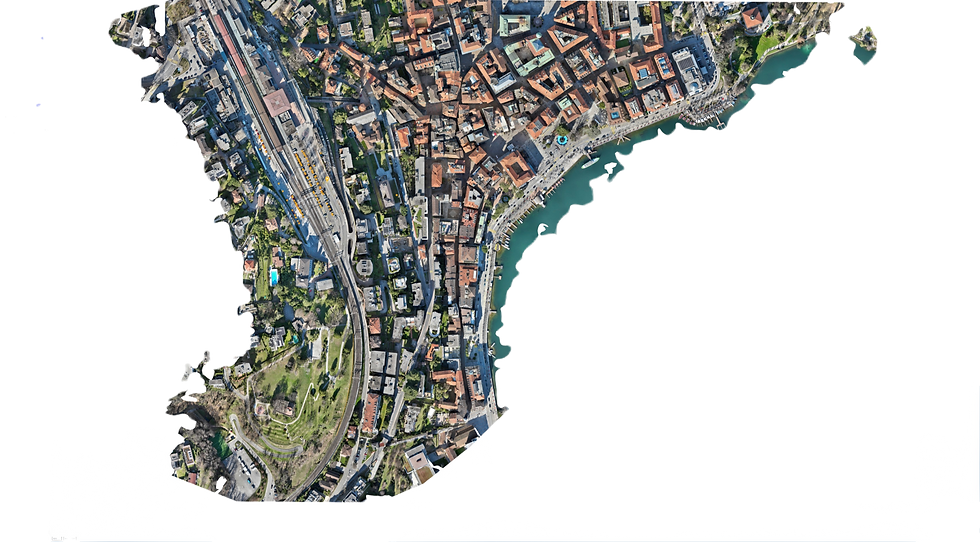
The Lugano Vision 3D Model project covers 21.5 hectares of the city and reflects a growing shift toward data-driven planning and urban intelligence. With an emphasis on precision, accessibility, and cross-disciplinary use, Blue Feather’s digital twin offers a dynamic platform to simulate and shape the future of urban environments.

A Comprehensive, High-Resolution Digital Twin of Lugano
The Lugano Vision 3D Model represents one of the most advanced digital replicas of an urban environment available today. By using Blue Feather’s proprietary Sky Cloud techniques, the model captures an extraordinary level of detail, offering urban planners, architects, engineers, and developers a comprehensive 3D map that is highly accurate and interactive.
This model offers insights into a variety of urban features, including topography, land use, vegetation, and environmental factors. With 1.8 cm resolution on the orthomosaic and a 7.3 cm resolution on the digital elevation model (DEM), users can explore the city with exceptional clarity, whether it's assessing building placement, simulating future projects, or evaluating environmental sustainability.

Supporting Data-Driven Decision Making
At its core, Blue Feather’s Lugano Vision 3D Model is designed to facilitate smarter, data-driven decision-making. Traditional urban planning methods often rely on static, 2D maps that fail to capture the full complexity of a city. Blue Feather’s digital twin, however, provides a dynamic, interactive environment where users can simulate and visualize the outcomes of various planning scenarios in real time.
This empowers city planners, architects, and developers to optimize projects before they begin, reducing costs, improving outcomes, and accelerating the development process. Furthermore, it helps identify potential challenges or opportunities in urban development — whether in infrastructure, transportation, or public services — giving stakeholders the tools to make more informed decisions.

Expanding Urban Intelligence Beyond Planning
The Lugano Vision 3D Model is not just a tool for city planners. Its versatile platform opens doors for a wide range of applications across industries:
Architecture & Urban Design: The model allows architects and designers to explore how new structures and developments will integrate into the existing urban fabric. It provides a realistic, scale-accurate visualization of how future projects will impact the cityscape.
Environmental Planning: By integrating topographical and environmental data, Blue Feather’s digital twin helps planners assess ecological impacts, optimize green space, and ensure sustainable development. Understanding elevation, vegetation health, and environmental factors in a 3D model helps cities maintain a healthy balance between development and preservation.
Infrastructure Development: From transportation networks to utilities, the digital twin enables planners and engineers to test how infrastructure will interact with the city’s existing systems. This simulation capability leads to better-prepared projects that consider everything from traffic flow to emergency access.
Public Services and Safety: With its precise mapping, the model offers first responders and urban managers better tools for disaster preparedness, traffic management, and public safety strategies. Simulating emergency scenarios within a 3D urban environment helps improve response times and effectiveness.

A Smarter, More Efficient Approach to Urban Mapping
The Lugano Vision 3D Model represents a significant leap forward in terms of accuracy, efficiency, and cost-effectiveness. Traditional methods of city mapping, such as ground surveys or satellite imagery, are often expensive and time-consuming. Blue Feather’s platform offers a more scalable and accessible solution by automating much of the data capture and processing, making it possible for municipalities of all sizes to benefit from this advanced technology.
With Blue Feather’s ability to deliver rapid, high-quality urban mapping, even small and medium-sized cities can access tools that were once available only to larger metropolises, leveling the playing field in urban planning and development.

Looking Toward the Future: Predictive Urban Planning
Blue Feather’s mission goes beyond creating high-fidelity digital models of cities. The company is positioning itself at the forefront of the smart city revolution by incorporating real-time data, predictive analytics, and AI-powered insightsinto its platform. These enhancements will allow cities to adapt and plan proactively rather than reactively, predicting future urban needs and environmental changes.
As cities become more dynamic and complex, the need for real-time urban simulation and predictive modeling will only grow. Blue Feather’s digital twin technology is designed to not only keep pace with these changes but also drive the evolution of smarter, more resilient urban spaces.
Conclusion: A New Era for Urban Planning
Blue Feather’s Lugano Vision 3D Model is a groundbreaking tool in the world of urban planning. By delivering an interactive, data-rich digital twin of the city, Blue Feather is empowering professionals across a wide range of industries to make smarter, more sustainable decisions. Whether for environmental management, infrastructure design, or public safety, the platform offers an unparalleled level of insight into the urban environment.
As cities around the world continue to grow and evolve, Blue Feather’s digital twins will be essential in shaping the cities of tomorrow — helping urban centers become more adaptable, efficient, and sustainable in the face of new challenges and opportunities.
For more information about Blue Feather’s digital twin technology and how it can transform your urban planning processes, visit www.bluefeather.digital.


Comments