

2D Orthomosiac


2D OrthopMap
Terrestrial 3D mapping is transforming the way industries operate. From construction and architecture to archaeology and urban planning, this cutting-edge technology captures precise, detailed data of real-world environments. With its ability to create accurate digital twins, businesses can streamline workflows, reduce costs, and make informed decisions."
About Terrestrial 3D Mapping



2D orthomosiac
2D Othrthophoto Map
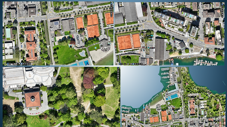
Blue Feather creates highly detailed 2D orthophoto maps with centimeter-level accuracy. These data-rich, georeferenced maps provide true-to-scale visuals and seamless integration with GIS, CAD, and BIM. Our orthomosaics deliver an unparalleled view of urban landscapes, essential for informed decision-making as cities embrace digital transformation.
2D Zurich

2D Othrthophoto Map
2D orthomosiac
Orthomosaics are more than just images — they’re data-rich, georeferenced 2D maps with centimeter-level accuracy. Generated efficiently from aerial imagery, they can achieve precision down to 0.25 cm, providing an exceptionally detailed and reliable foundation for urban planning, spatial analysis, and informed decision-making.

.jpeg)


yarrow Point

X

2D Orthomosiac


Blue Feather creates highly detailed 2D orthophoto maps with centimeter-level accuracy. These data-rich, georeferenced maps provide true-to-scale visuals and seamless integration with GIS, CAD, and BIM; our ortho mosaics deliver an unparalleled view of urban landscapes—essential for informed decision-making as cities embrace digital transformation.
Accuracy
2D Othrthophoto Map

