


Bluefeather leverages advanced imaging technologies to capture diverse geospatial data. Our solutions include RGB and multispectral imaging across various light spectrums, infrared sensing, laser-based scanning, and airborne monitoring to map city carbon emissions and pollution at scale. This comprehensive data suite equips city officials with precise insights to optimize urban planning, enhance infrastructure efficiency, and support smarter decision-making.
imaging technologies


3D City Models
Digital twin
Blue Feather creates hyper-realistic digital twins of cities—highly detailed 3D models reconstructed from real-world imagery and advanced photogrammetry. With centimeter-level accuracy, these models mirror the real world with exceptional precision. They integrate real-world data to unlock multi-layered insights, enable real-time simulations, and provide scalable solutions to today’s urban challenges.


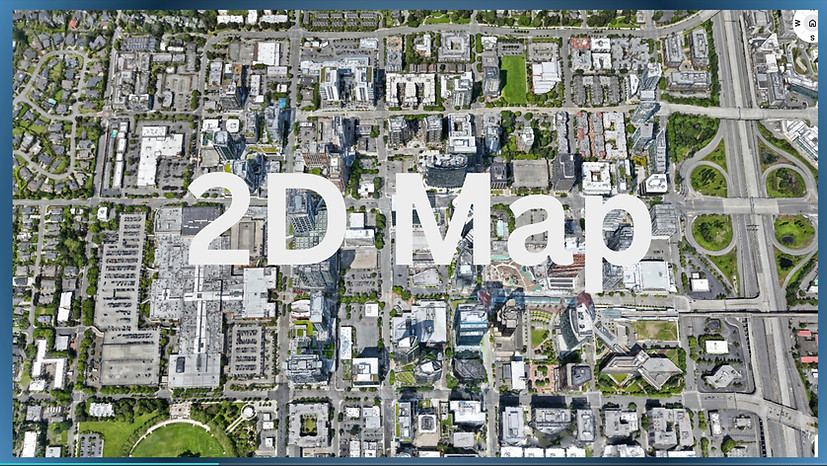
2D Othrthophoto Map
2D orthomosiac
Blue Feather creates highly detailed 2D orthophoto maps with centimeter-level accuracy. These data-rich, georeferenced maps provide true-to-scale visuals and seamless integration with GIS, CAD, and BIM; our ortho mosaics deliver an unparalleled view of urban landscapes—essential for informed decision-making as cities embrace digital transformation.


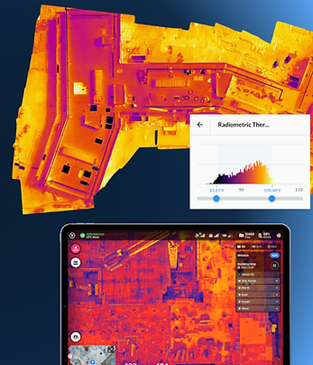
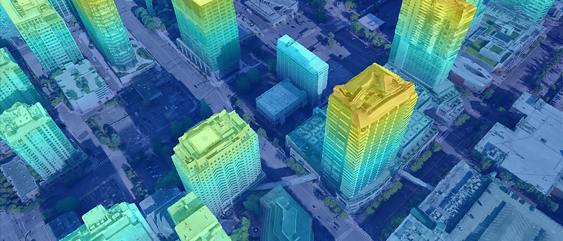
Blue Feather Heat Signature 2D Maps provide a comprehensive view of the city’s heat signature, revealing temperature variations across surfaces. These detailed maps identify urban heat islands, showcasing hotspots such as rooftops, asphalt, and industrial areas. Enhanced with data on vegetation and cooling effects, our maps drive targeted strategies for heat mitigation, energy efficiency, and public health.
2D Thermal Maps


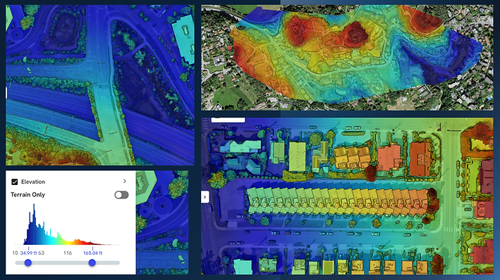
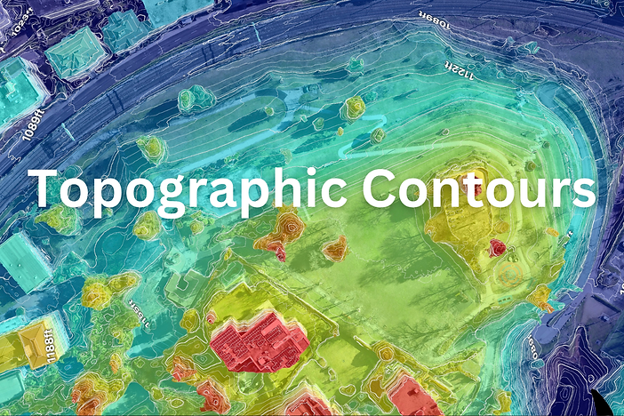
Digital Elevations Models
Blue Feather offers cutting-edge Digital Terrain Models (DTM), Digital Surface Models (DSM), and intricate contour lines in stunning 2D and 3D visuals. DTMs reveal bare earth features, while DSMs showcase all surface elements—ideal for flood modeling and city planning. Navigate these detailed landscapes in real time with our interactive 3D viewer, seamlessly overlaying terrain and structural data for precise insights

Vegetation health


Blue Feather’s 2D Vegetations Health Maps and advanced imaging brings urban vegetation into a new dimension of visibility by capturing wavelengths beyond human sight—such as near-infrared and red-edge light—to detect early signs of plant stress, water loss, disease, and nutrient deficiency before they become visible. These insights enable cities to protect green infrastructure with scientific precision, as data empowers planners to reduce urban heat islands, improve air quality, and enhance biodiversity.


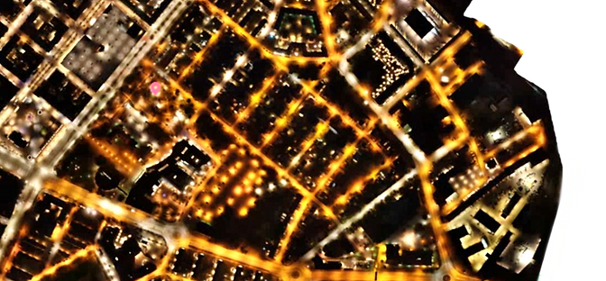
City Light Maps
Blue Feather delivers ultra-precise 2D night maps that reveal light distribution, intensity, and pollution across entire urban areas. Using NIR, advanced imagery, and machine learning, we optimize image quality to capture every detail with centimeter-level accuracy. These maps empower cities to reduce energy waste, improve lighting strategies, and enhance nighttime livability—an essential layer in any digital twin.

Laser Scanning
Blue Feather is transforming urban planning with cutting-edge airborne Laser Scanning technology that leverages laser pulses to create highly detailed, city-scale point clouds. Our solutions enable precise vegetation penetration and accurate terrain modeling with superior accuracy—delivering cost-effective applications like landslide monitoring, infrastructure inspections, vegetation management, and more. Compared to traditional methods, our Laser Scanning mapping is faster, more affordable, and scalable for smarter, safer cities.


Urban Air Monitoring
Blue Feather's digital twin platform revolutionizes Urban Air Monitoring through cutting-edge Air Quality Analytics and City Emissions Intelligence, 3D interactive maps . Our pioneering geospatial mapping technology creates a truly comprehensive, real-time atmospheric pollution visualization and analysis system. Our next-generation monitoring captures: , Dynamic Air Quality Signatures , Live Urban Emission Fingerprints Multi-spectral Gas and Particulate Detection , Precision Pollutant Tracking: CO₂, NO₂, CH₄, and O₃. This powerful environmental intelligence platform transforms how cities understand their air quality, enabling predictive decision-making that proactively protects public health, accelerates sustainability goals, and future-proofs urban environments.


Twin Technology

The world’s most intricate details—reimagined in the digital realm.
Blue Feather’s Twin Technology introduces a new era of urban mapping and spatial intelligence. Through our specialized pipeline leveraging Gaussian/Dawson Splatting technology, we deliver real‑time 3D reconstructions and precision aerial capture to craft photorealistic digital twins, bringing cities to life like never before.
Photographic Precision, Accelerated
Our pipeline captures the finest details— reproducing glass façades, intricate geometries, and complex urban structures with unmatched realism. By combining advanced splatting techniques with scalable processing, Blue Feather enables faster, more efficient city-scale modeling while setting a new benchmark for immersive, real-time digital reconstructions.


Vector Analytics
Revolutionizing Urban Intelligence with Innovative Vector Analytics
Vector Analytics is at the forefront of transforming urban analysis through advanced geospatial visualizations and intelligent spatial analytics and numerical data quantification tools. These vector overlays automatically detect and quantify key urban elements—including schools, transportation networks, parks, residential communities, parking facilities, and green spaces—while providing deep insights into population density, topography, elevation, and flood risk.
By seamlessly overlaying vector data on 2D maps and 3D models, Vector Analytics reveals complex spatial relationships, empowering urban planners and decision-makers to explore, analyze, and manage city environments with unprecedented precision and actionable insights.


Vector Analytics

Blue Feather is the spatial engine that powers the cities of tomorrow. We create high-resolution 3D models, immersive digital twins, and real-time geospatial platforms, laying the digital foundation for smart city development. Our systems are designed for seamless integration with IoT networks, emergency response, autonomous infrastructure, urban analytics, and climate simulations. This makes Blue Feather not just a mapping company, but the essential backbone on which intelligent, adaptive cities are built.
A foundation for smart cities


smart cities


Videos


Digital Twins
Sky Cloud


Blue Feather Empowering the City of the Future

Let's Discuss
Your Next Project
Phone
+41 78 332 37 10
Adress
Blue Feather AI
Via Antonio Ciseri 3, 6900 Lugano
